Nullarbor Attractions
Many travellers describe the drive across Nullarbor as
- Nullar-boring
- 12 hours into madness
- it's empty. nothing to see
and much more.
However, contrary to the statements mentioned above, surprisingly, Nullarbor has a lot of attractive things to offer to the travellers.
The list is huge and hence I thought it is worth creating a separate page for this.
I have listed these attractions in the order of their presence from Ceduna (SA) to Norseman (WA).
Here you go.
Table of Contents
- Nullarbor Links - World's Longest Golf Course
- Australia's biggest Windmill at Penong (SA)
- Rare signpost with Camel near Yalata (SA)
- Nullarbor Plain (SA)
- Whale Watching at Head of the Bight (SA)
- Roadhouses
- Nullarbor Scenic Flights
- Murrawijinie Caves near Nullarbor Roadhouse
- Bunda Cliffs
- Runway on the Highway
- Border Village (border of SA and WA)
- Eucla (WA)
- Madura Pass Lookout (WA)
- Eyre Bird Observatory
- Cocklebiddy Roadhouse
- Cocklebiddy Cave
- 90 Mile Straight - Australia's Longest Straight Road
- Caiguna Blowhole
- Balladonia Roadhouse Museum
- The World's Longest Straight Railway Track
- Wildlife
- 360° View of Horizon
- Friendly Wave
- I Crossed the Nullarbor - Certificate & Sticker
Nullarbor Links - World's Longest Golf Course
Are you a Golf lover? If yes, then I have great news for you.
Have you ever imagined World's Longest Golf course is located on the desert?
Yes. That's true. Nullarbor Golf Links is the World's Longest Golf course. It is an 18-hole par 72 Golf course situated along 1,365 KM of the Eyre Highway (A1) from Ceduna (SA) in the east to Kalgoorlie (WA) in the west.
Here is the photo of the Golf course from the official website of Nullarbor Links.
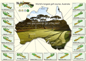
As you can see, each hole is located on the participating town or roadhouse across the Nullarbor.
If you want to play Golf at Nullarbor Links, you can contact the Visitor Information Centre in Ceduna (SA), Kalgoorlie (WA) or Norseman (WA) depending upon your direction of travel.
For more details, here is the link to the official website of Nullarbor Links.
Australia's biggest Windmill at Penong (SA)
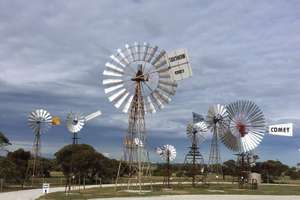
Penong (SA) is a small settlement and it takes the pride of hosting Australia's biggest windmill (traditional style) as well as Windmill Museum.
This is located very close to the Eyre Highway (A1). So, why not stop here and take a look?
Here is the location of Windmill museum in Google Maps.
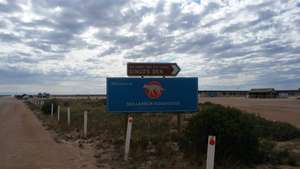
Rare signpost with Camel near Yalata (SA)
In Australia, it's quite common to see a signpost with a kangaroo. However, have you seen a signpost with a camel?
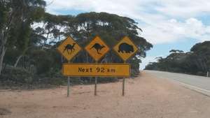
When you drive across the Nullarbor, you'll see signposts with a camel in a lot of places. The one shown above is near Yalata (SA) and this is just the beginning. As you drive further, you'll see many such signposts.
However, I didn't see any camel near the highway. Did you see one?
This sign also indicates that you are in a desert.
By the way, how did camels come to Australia?
Here is a short story.
Camels were brought to Australia from Afghanistan and British India back in the 1940s. They were utilised by the workers on the outback area to lay the railway track between Adelaide (SA) and Darwin (NT). When the railway track was completed, these camels were not needed for any other work. Initially, the plan was to kill all of them. Later, the workers thought that these camels were not going to survive in very hot conditions. So, they thought that let the camels die on their own in the outback area and the desert. For their astonishment, these camels survived the hot conditions and their generations continued.
Even today, it is evident that there are a lot of camels in outback areas and the deserts.
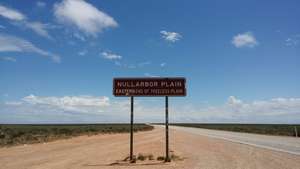
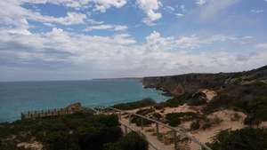
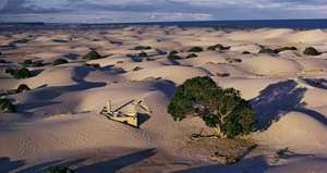
Nullarbor Plain (SA)
As you drive further from Yalata, you'll enter the actual Nullarbor Plain. You can find the famous signpost as shown below.
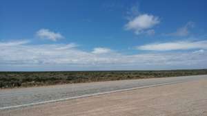
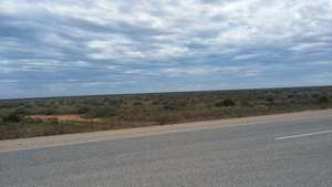
How does Nullarbor Plain look like? Here are some sample photos.
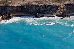
Whale Watching at Head of the Bight (SA)
If you are planning to drive across Nullarbor between May and October, then you have got a great opportunity to watch Southern Right Whales at Head of the Bight.
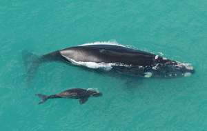
Whale watching season is from June to October. Head of the Bight is the place where you can see many whales in Australia.
As you drive further from the Nullarbor Plain signpost, within 5-10 minutes, you'll see a signpost towards Head of the Bight - Whale Watching Centre. Head of the Bight is located 12 KM off the Eyre Highway. The road to the Head of the Bight is fully sealed and hence even 2WD cars can go there.
There is an entry fee on both Whale watching season and offseason. The entry fee will give you access to the whale watching platforms as shown in the below photos. Also, you can see Bunda cliffs as well.
For more information about Whale watching, please contact the Visitor Information Centre at the Head of the Bight. The details are given below.
Head of the Bight - Whale Watching Centre
Eyre Highway, Nullarbor, SA 5690Ph: (08) 8625 6201
E-mail: whalewatching@headofbight.com.au
Web: http://www.headofbight.com.au
Location in Google Maps
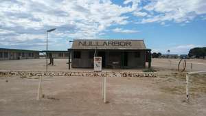
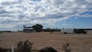
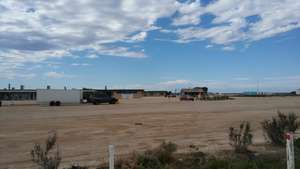
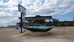
Roadhouses
One of the attractions of the Nullarbor Plain is roadhouses. They are your saviour to cross the Nullarbor as they provide you car fuel, food, water and accommodation facilities.
So, why not stop on the roadhouse and have a look around?
When you drive further west from Head of the Bight, within 20 minutes, you'll reach Nullarbor Roadhouse. Here are a few photos from the Nullarbor Roadhouse (SA).
Nullarbor Scenic Flights
Did you know that scenic flights are operating out of the Nullarbor Roadhouse?
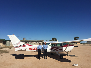
Chinta Air operates scenic flights from Nullarbor Roadhouse during winter. The scenic flight will take you above the Head of Bight for whale watching and the Bunda cliffs.
You can check the below link for more details of scenic flights.
Chinta Air Scenic Flights from Nullarbor Roadhouse
Also, you can contact Nullarbor Roadhouse for more details.
Murrawijinie Caves near Nullarbor Roadhouse
Nullarbor Plain has a lot of caves. One of the famous caves is Murrawijinie caves.
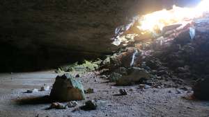
This cave is open to the public and it is located just 10 KM north of Nullarbor Roadhouse. The road to the caves is a dirt road. However, it is accessible through 2WD cars.
Before heading to the caves, just check with the staff at Nullarbor Roadhouse for directions and other safety measures.
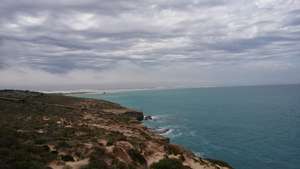
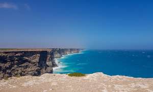
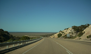
Bunda Cliffs
The magnificent Bunda cliffs form a part of the longest uninterrupted line of sea cliffs in the world. They extend for approximately 100 KM along the Great Australian Bight between Head of Bight (SA) and Border Village (SA).
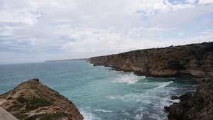
From the Head of the Bight (SA) to the Border Village Roadhouse (SA), you can view the Bunda cliffs at 5 different places along the Eyre Highway. They are
Whale watching platforms at Head of the Bight. You need to pay an entry fee for this one
remaining 4 lookout points are located between Nullarbor Roadhouse (SA) and Border Village Roadhouse (SA). No entry fee for these lookout points. They are open to the public all the time
These 4 lookout points are located off the Eyre Highway and accessible through a gravel road. There are signposts for these lookout points. The signposts won't mention the text "Bunda Cliffs". Instead, it has a camera symbol indicating photo opportunity.
Runway on the Highway
Have you seen a runway airstrip on a highway? No?
Nullarbor will give you an opportunity to see this. Not just one, there are four runways on the Eyre Highway across the Nullarbor Plain.
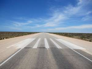
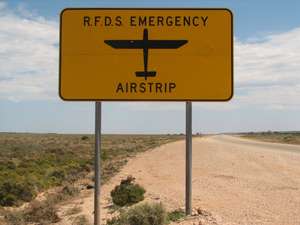
These runways are used by the RFDS (Royal Flying Doctors Service) planes to pick up people who need emergency attention.
Before you approach these runways, you can see a signpost like this.
You can find these runways in the following places.
between Nullarbor Roadhouse (SA) and Border Village Roadhouse (SA)
between Eucla (WA) and Mundrabilla Roadhouse (WA)
between Mundrabilla Roadhouse (WA) and Madura Roadhouse (WA)
between Caiguna Roadhouse (WA) and Balladonia Roadhouse (WA)
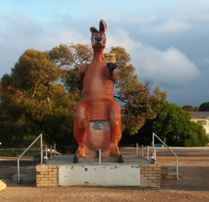
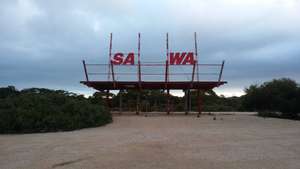
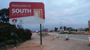
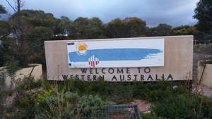
Border Village (border of SA and WA)
Border Village Roadhouse (border of SA & WA) is a must stop for many attractions at one place.
Anyway, you need to stop here for Quarantine Checkpoint. So, why don't spend some time to look at these attractions?
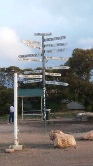
- Big Kangaroo with a vegemite
- Signpost with 1000s of KM to Australian capital cities
- Border of SA & WA
- Welcome to SA & WA signs
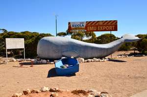
Eucla (WA)
Eucla (WA) is not a roadhouse. It is a small settlement and it is very close to Border Village. You can reach Eucla (WA) within 10 minutes of drive from Border Village.
Eucla is another must stop for quite a few attractions and a little bit of history.
Ruins of Old Telegraph Station
Roughly 100 years ago, Eucla had a Telegraph Station that helped Western Australia to communicate with Colonies in the East as well as the outside world. This station was abandoned later on due to many reasons. However, we can still see some ruined parts of the building.
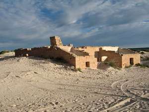
Eucla Sand dunes
You can see sand dunes around the ruined Telegraph Station at Eucla.
Leeuwin Way Concrete Whale
Eucla Pass
As you come out of Eucla and join the Eyre Highway, you can see a signpost of Eucla Pass. Eucla Pass is where the Eyre Highway enters Roe Plains. Roe Plains is considered to be the basin of Nullarbor Plain.
From Eucla Pass, you'll drive on the Roe Plains till you reach Madura Pass.
Madura Pass Lookout (WA)
Just immediately after Madura Roadhouse, you can see Madura Pass signpost. You'll have a little uphill where there is a lookout point on the right side of the Highway.
This lookout point gives you some breathtaking sceneries of Roe Plains.
Madura Pass is where Eyre Highway exits Roe Plains and rejoins Nullabor Plain.
Eyre Bird Observatory
Eyre Bird Observatory is a remote research station to collect information about birds and wildlife. It is the most isolated research facility in Australia. It is located 50 KM south-east of Cocklebiddy Roadhouse (WA).
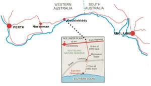
You need a 4WD vehicle to visit Eyre Bird Observatory. With a 2WD vehicle, you can go up to the Lookout point (as shown in the above map). After that, it is a 4WD track only.
Transport is not provided for day visitors. There is limited accommodation available at the Observatory.
The contact details of the Observatory are given below.
Eyre Bird Observatory
PMB 32, Cocklebiddy via Norseman WA 6443
Ph: (08) 9039 3450
E-mail: eyre@birdlife.org.au
Web: https://birdlife.org.au/visit-us/observatories/eyre
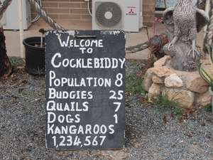
Cocklebiddy Roadhouse
A board kept in front of Cocklebiddy Roadhouse attracts a lot of visitors.
Are you curious to know why?
The board tells the story.
Cocklebiddy Cave
Nullarbor Plain has a lot of caves. Of which, the most famous one is the Cocklebiddy cave.
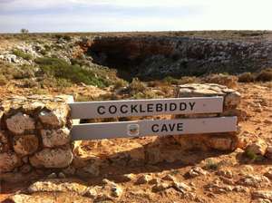
Cocklebiddy cave is considered to be one of the largest caves in the world. It has more than 6 KM of underwater passages.
It attracted a lot of diving groups around the world and the divers have explored more than 6 KM of the cave's underwater passages.
Cocklebiddy cave is mainly for the experienced cave diving groups only. Not for common public.
This cave is located 10 KM north-west of Cocklebiddy Roadhouse (WA). You can contact the Roadhouse to know more about getting into this cave.
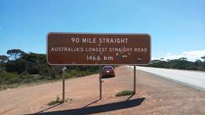
90 Mile Straight - Australia's Longest Straight Road
One of the great opportunities you get when you drive across the Nullarbor is that you'll drive on Australia's longest straight road of 146 KM.
This is the iconic part of the journey and this is one of the reasons why people wanted to drive across the Nullarbor.
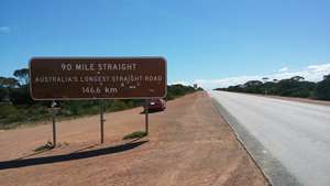
The road is straight for 146 KM without any bend or turns. However, the road is not flat. There are slight steeps and slopes at some points. Due to this, you can't see the straight road as a single straight line for the entire distance either in the front or on your car's back view mirror.
This straight road is located between Caiguna Roadhouse (WA) and Balladonia Roadhouse (WA). On the east side, this road begins just outside of Caiguna Roadhouse (WA) and ends approximately 30 KM before Balladonia Roadhouse (WA).
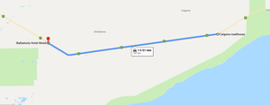
Open Australia's longest straight road in Google Maps
The beginning of the straight road is well signposted on both the ends. So, when you drive (in either direction), don't forget the great photo opportunity.
Caiguna Blowhole
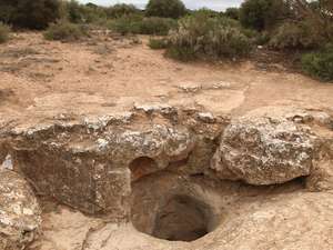
One of the surprising things that Nullarbor offers to visitors is blowholes. Also, one of the blowholes that is easily accessible by car is the one near Caiguna Roadhouse (WA).
It is located just 5 KM west of Caiguna Roadhouse (WA) and just 10 metres off the Eyre Highway. Also, this is well signposted and there is a car park.
Open Caiguna Blowhole in Google Maps
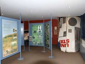
Balladonia Roadhouse Museum
There was an interesting story about Balladonia.
What is that?
Balladonia became world famous back in 1979. NASA's Skylab space station crashed and some parts of the space station littered the area near Balladonia. So, the local Ranger fined American Government an amount of $400. American President spoke to the Australian Prime Minister and apologised for the incident. Then, the fine was reversed.
Balladonia Roadhouse (WA) has a museum where you can see all the details about this incident. There is no entry fee for this museum.
The Museum has created a model of the debris and kept it here for visitors.
The World's Longest Straight Railway Track
By now, you knew that Nullarbor hosts Australia's longest straight road.
Did you also know that Nullarbor hosts the World's longest straight railway track?
Yes. The world's longest straight railway track runs across the Nullarbor Plain. It is a dead straight track for a distance of 477 KM. It is also known as 300 Mile Straight.
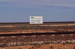
When you drive on the Eyre Highway, you won't see the railway track. However, this is something interesting to know.
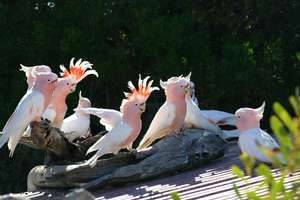
Wildlife
Nullarbor is home to a lot of wildlife such as kangaroos, emus, wallabies, camels, dingos, wombats, etc. Their activities are more in the night as well as at dawn and dusk.
Depending upon the time of your travel, you may see some wildlife.
I didn't see any wildlife during my two days of driving across the Nullarbor. However, the fact is that there is a lot of wildlife across the Nullarbor.
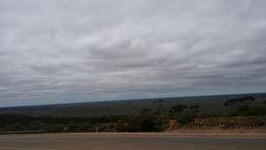
360° View of Horizon
The flat terrain combined with treeless plain in some stretches of Nullarbor gives an opportunity to see the horizon on all the four directions. This is great for nature lovers and a perfect opportunity for great photos.
Friendly Wave
On the Nullarbor Plain, you'll be surprised to see a friendly wave from other travellers and truck drivers coming in the opposite direction.
Within 30 minutes, you'll build a habit of waving at other travellers coming in the opposite direction.
This friendly wave is an attraction in itself.
I Crossed the Nullarbor - Certificate & Sticker
Did you know that there is I Crossed the Nullarbor certificate and sticker for your car bumper?
In the past (decades ago), crossing the Nullarbor was an adventure and a challenge. So, to encourage the travellers, the Visitor Information Centres in Ceduna (SA) and Norseman (WA) used to give certificates to those who cross the Nullarbor successfully.
These days, crossing the Nullarbor is relatively easy. Thanks to the Roadhouses and the sealed road.
However, as a tradition, you can still purchase the certificate and a sticker for your car.
I didn't buy them. But, you can buy one if you want.
Comments