My Epic Drive from Melbourne to Perth
Even though the content of this website is based on my driving experience from Melbourne to Perth, I thought I should still write about my journey without repeating or duplicating much of the content present on other sections of this site.
This includes my preparation, itinerary, some of the places I visited and my feedback about this trip.
Table of Contents
My Preparation
When the plan to drive from Melbourne to Perth was finalised, I was damn happy and super excited. I knew it was a rare opportunity for me considering my work and family circumstances. I thought I'll utilise this opportunity to visit and experience some of the remote areas of Australia, something for which I have been waiting for a long time.
Here are some of my preparations for this drive.
Since I had limited time, I decided to drive in 5 days (with an extra day or two in case of any emergencies)
I chose 5 days based on my driving capacity (on an average, 700 KM or 7 hours of driving per day)
I booked accommodation for all 5 days before starting my trip
My car was serviced 9 months before this trip and it was not due for another service. Hence, the car didn't require any preparation other than petrol and checking tyre pressure
I already had RACV emergency roadside assistance for my car. So, I didn't have to purchase one
I decided to drive only during daylight hours (between 7 AM and 7 PM). No night driving
I decided to take a small break every 2 hours during the drive
I decided to eat outside all the time. Hence, I didn't take much food items. Just a few packs of snacks only
I sent a copy of my itinerary to my wife including the places where I stay with their contact details
I identified few places to visit within this limited time frame
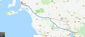
My Drive Itinerary
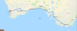
| Day | Route | Distance (KM) | Drive Time |
| 1 | Melbourne (VIC) to Adelaide (SA) | 730 | 8 hr |
| 2 | Adelaide (SA) to Ceduna (SA) | 780 | 8 hr & 15 min |
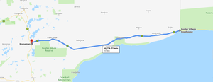
| 3 | Ceduna (SA) to Border Village Roadhouse (SA) | 490 | 5 hr |
| 4 | Border Village Roadhouse (SA) to Norseman (WA) | 725 | 7 hr & 20 min |
| 5 | Norseman (WA) to Perth (WA) | 780 | 8 hr & 40 min |
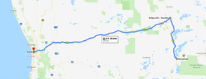
Open this itinerary in Google Maps
As you can see, I had allocated 2 complete days to drive across the Nullarbor Plain. The reason was that I wanted to explore and spend more time on the Nullarbor to experience the unique Australian outback area.
Day 1: Melbourne (VIC) to Adelaide (SA)
Here are the quick facts about driving from Melbourne to Adelaide.
Route: The inland route from Melbourne (VIC) to Adelaide (SA)
Distance: 730 KM
Drive Time: 8 hours. It doesn't include any break
States: You will drive across two States. They are Victoria (VIC) and South Australia (SA)
Time zones: There are 2 time zones on the way. Hence, you'll need to adjust your clock once when you cross the VIC/SA border
Car fuel, food and accommodation: Lot of options on the way. Don't worry
Mobile Phone coverage: Telstra phone provides coverage throughout the stretch
In my opinion, driving from Melbourne to Adelaide is the difficult leg of the whole journey. The reason was you'll have traffic when you leave Melbourne and when you enter Adelaide. The freeway (M1 & M8) are for a maximum of 200 KM only. Remaining 500 KM is highway (A8) only. In that highway, there are a lot of small towns and villages where the speed reduces to 50 KM. Hence, you can't simply drive at 100 KM throughout the stretch. This slows down your journey. Hence, plan accordingly.
Also, plan to leave Melbourne in such a way that you should avoid city traffic. Otherwise, your journey will be longer.
Fortunately, I live in the western suburbs of Melbourne. Hence, it was easy for me to reach the Western Freeway (M8) within 5 minutes of leaving my home.
As you drive further on M8 (Western Fwy) towards Ballarat, the landscape changes quickly to the beautiful countryside with farming in most of the places.
Ballarat (VIC):
Within 90 minutes of leaving Melbourne, you'll arrive at Ballarat. This city is known for its gold rush history. If you are new to Ballarat, this is a must stop to explore the history of the gold rush and Victoria's gold fields.
A must see tourist attraction here is Sovereign Hills
Grampians National Park (Halls Gap):
After Ballarat, you'll arrive at two regional towns Ararat and Stawell.
From these two places, you can go to Halls Gap which is located at the heart of Grampians National Park. This is another must-see attraction for spectacular lookout areas from the mountains, Mackenzie waterfalls, bushwalking and trekking related activities.
Horsham (VIC):
Horsham is a regional city and it has plenty of food and accommodation options.
If you have time, you can plan to visit Silo Art Trail. This is Australia's largest outdoor art gallery linking some of smallest towns in Victoria.
Border of Victoria and South Australia:
From Horsham, within 90 minutes, you'll reach the border of Victoria and South Australia.
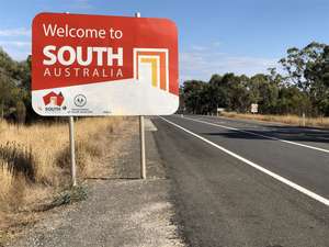
These two states are in different time zones. Hence, you'll need to adjust your clock here. Your smartphone will automatically change to South Australian time zone.
Adelaide (SA):
I liked the entry to Adelaide through Adelaide Hills. There is a 7 KM long steep descent on the Adelaide Hills area that takes you into the city directly.
If your car is pulling a caravan or a trailer, then you need to be a bit careful on how to handle this stretch in control.
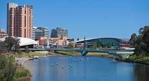
Also, try to plan in such a way that you avoid the city traffic when you enter and exit Adelaide.
I chose to stay at Highway 1 Caravan & Tourist Park located at Bolivar. The reason for choosing this is that it is located in the northern suburbs of Adelaide. This is outside of the city area. Also, the next day, when you begin your journey, the moment you come out of the caravan park, you will be on Princes Hwy (A1) that takes you to Port Augusta. Hence, no need to deal with city traffic.
Day 2: Adelaide (SA) to Ceduna (SA)
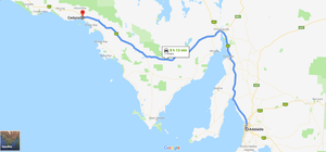
Here are the quick facts about driving from Adelaide to Ceduna.
Route: The inland route from Adelaide (SA) to Ceduna (SA)
Distance: 780 KM
Drive Time: 8 hours & 15 minutes. It doesn't include any break
States: You will drive in South Australia (SA) State only
Time zones: You'll be on South Australia time zone only
Car fuel, food and accommodation: Many options on the way. Don't worry
Mobile Phone coverage: Telstra phone provides coverage throughout the stretch
Since I stayed in the northern suburbs of Adelaide, when I started my journey towards Ceduna, there was absolutely no traffic for me. Within five minutes, I was on Princes Hwy (A1).
Driving from Adelaide to Ceduna was comparatively easier for me than Melbourne to Adelaide stretch as you'll drive on 110 KM most of the times. Also, there is less number of towns in between.
Port Wakefield (SA):
Port Wakefield is the first town that you get after Adelaide. You can stay here if you plan to explore the Yorke Peninsula.
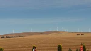
Snowtown (SA):
After Port Wakefield, on the way to Port Augusta, when you arrive near Snowtown, you can see windmill farm on your left-hand side.
Port Augusta (SA) - Crossroads of Australia:
After a drive of 3 hours and 30 minutes from Adelaide, you'll arrive at Port Augusta. It is known as Crossroads of Australia.
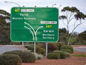
This city got the name "crossroads" because from Port Augusta, you can go
- west to Perth
- north to Darwin
- east to Sydney
- south to Adelaide and Melbourne
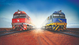
In addition to the above, the following two great Australian trains intersect at Port Augusta.
- Indian Pacific (Perth to Sydney)
- The Ghan (Adelaide to Darwin)
Port Augusta is a good place to stay and it has quite a few attractions if you have time.
From Port Augusta, you'll drive on Eyre Highway (A1) till you reach Norseman (WA).
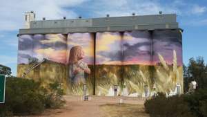
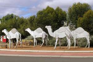
Kimba (SA) - Halfway Across Australia:
When you arrive at Kimba, you can be happy. The reason is that you have crossed half of the continent.
Yes, Kimba marks halfway across Australia. When you enter Kimba, you can see these boards.
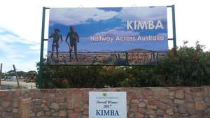
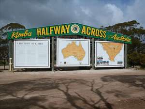
When a crow flies from east coast to west coast, Kimba marks half the way. To mark this, there is a status of big Galah beside the Eyre Highway (A1).
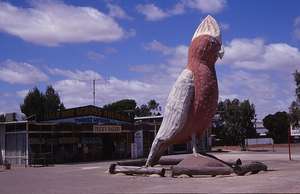
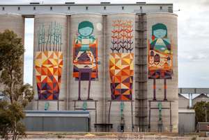
If you go towards the city centre, you can see a magnificent mural painting on the giant grain silos.
Ceduna (SA) - Oyster Capital of Australia:
After Kimba, you'll come across small towns such as Kyancutta, Wudinna, Minnipa, Poochera and Wirrulla before you arrive at Ceduna.
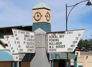
Ceduna is a small coastal town and it is the oyster capital of Australia. It is a good place to stay and it has quite a few accommodation options. Also, it has some nice attractions if you have time.
Ceduna is the last major town before you head towards Nullarbor Plain. Hence, it is the best place to fill your car tank and do grocery shopping, if any.
After Ceduna, the options are very limited and expensive.
Day 3: Ceduna (SA) to Border Village Roadhouse (SA)
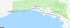
Here are the quick facts about the driving from Ceduna (SA) to Border Village Roadhouse (SA).
Route: Ceduna (SA) to Border Village Roadhouse (SA) across the Nullarbor Plain
Distance: 490 KM
Drive Time: 5 hours. It doesn't include any break
States: You will drive in South Australia (SA) State and you'll reach the border of South Australia and Western Australia
Time zones: There are 2 time zones on the way. Hence, you'll need to adjust your clock as soon as you reach Border Village Roadhouse (SA)
Car fuel, food and accommodation: Very limited and expensive. Roadhouses across the Nullarbor are the only option for you. Hence, you must be prepared for this stretch
Mobile Phone coverage: Telstra phone provides coverage only near the roadhouses. There is no coverage on other areas
This was the day for which I have been waiting for. This is the reason why I opted to drive from Melbourne to Perth.
Yes. I am talking about the Nullarbor Plain. I would say your Melbourne to Perth trip doesn't begin until you hit the Nullarbor.
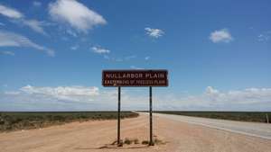
Driving across the Nullarbor is a unique Australian outback experience. You must be prepared for this stretch of the journey.
Considering Nullarbor's vastness, emptiness and limited fuel, food & accommodation options, I have provided in-depth details about driving across the Nullarbor in a separate section. You can check the below posts. Hence, I am not going to repeat them here.
Driving across the Nullarbor Plain
Roadhouses across the Nullarbor Plain
Quarantine Checkpoint
Confusing Time zones across the Nullarbor Plain
Misconceptions about Nullarbor
Attraction across the Nullarbor Plain
After about 5 hours of drive from Ceduna across the Nullarbor Plain, you'll arrive at Border Village Roadhouse. This is the border of South Australia and Western Australia.
Border of South Australia and Western Australia follows border time zone and hence you'll need to adjust your clock here. Your smartphone won't detect this time zone and hence don't rely on it.
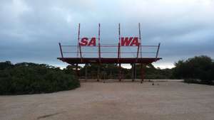
Border Village Roadhouse has quite a few photo opportunities. Check it out.
Day 4: Border Village Roadhouse (SA) to Norseman (WA)
Here are the quick facts about the driving from Border Village Roadhouse to Norseman.
Route: Border Village Roadhouse (SA) to Norseman (WA) across the Nullarbor Plain
Distance: 725 KM
Drive Time: 7 hours & 20 minutes. It doesn't include any break
States: You will drive on both South Australia and Western Australia
Time zones: There are 2 time zones on the way. Hence, you'll need to adjust your clock as soon as you reach Caiguna Roadhouse (WA)
Car fuel, food and accommodation: Very limited and expensive. Roadhouses across the Nullarbor are the only option for you. Hence, you must be prepared for this stretch
Mobile Phone coverage: Telstra phone provides coverage only near the roadhouses. There is no coverage on other areas
This stretch of the journey is also part of the Nullarbor. Hence, my other posts about Nullarbor will provide you in-depth details for this stretch too.
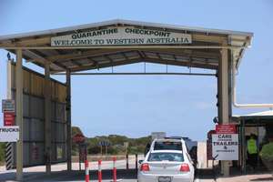
As soon as you start your journey at Border Village Roadhouse, you must stop your car at the Quarantine Checkpoint located on the border of South Australia and Western Australia. Your car will be inspected by a Quarantine Inspector.
Caiguna Roadhouse (WA):
After a drive of 3 hours and 30 minutes from Border Village Roadhouse, you'll arrive at Caiguna Roadhouse (WA). This comes under the Western Australia time zone. Hence, you'll need to adjust your clock as soon as you reach here.
Caiguna Roadhouse is where Australia's longest straight road of 146 KM begins. This is also known as 90 Mile Straight.
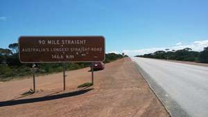
This is one of the highlights of this trip. This is another reason why I chose to drive from Melbourne to Perth.
When you complete the drive on Australia's longest straight road, you'll arrive at Balladonia Roadhouse (WA).
Great Western Woodlands:
What I observed was that the landscape from Ceduna (SA) to Balladonia Roadhouse (WA) for about 1,000 KM is almost the same. It doesn't change much. You'll see Nullarbor's treeless plain in some areas and then less number of trees in other areas. Overall, there is a lot of vastness, emptiness and nothingness.
However, after Balladonia Roadhouse (WA), when you drive towards Norseman (WA), the landscape changes drastically. The reason is you'll enter Great Western Woodlands.

In this stretch, you'll drive across thick forest located on the Fraser Ranges. All of a sudden, you'll see heaps of huge and large number of trees. It is a dramatic landscape change. This will continue until you reach Norseman (WA).
Norseman (WA):
When you reach Norseman, you are completing your drive across the Nullarbor Plain. You are now back into civilisation.
At Norseman, you are back into your regular life with quite a few options for fuel, food and accommodation.
Day 5: Norseman (WA) to Perth (WA)
Here are the quick facts about the drive from Norseman to Perth.
Route: The inland route from Norseman (WA) to Perth (WA) via Kalgoorlie (WA)
Distance: 780 KM
Drive Time: 8 hours & 35 minutes. It doesn't include any break
States: You will drive in Western Australia (SA) State only
Time zones: You'll be in Western Australia time zone only
Car fuel, food and accommodation: Quite a few options on the way. You need not worry much
Mobile Phone coverage: Telstra phone provides coverage on most of the areas in this stretch
Since I opted for the inland route, from Norseman, I drove north towards Kalgoorlie.
If you choose the coastal route, then you'll need to drive south towards Esperance (WA).
Kalgoorlie (WA):
From Norseman, within 2 hours drive, you'll arrive at Kalgoorlie. This outback city is known for its history of goldrush and gold mining. If you are new to Kalgoorlie or Western Australia, then this is a must stop for its history and quite a few attractions around.
A must see attraction in Kalgoorlie is the Super Pit.
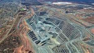
Super Pit is the largest open-cut mines on earth and the biggest gold mine in Australia. It is 3.7 KM long, 1.5 KM wide and 600 metres deep. Tons of ounces of gold are harvested here every year.
There is a Super Pit lookout area for the public. Also, there is a guided tour of the Super Pit. If you have time, go for the Super Pit tour.
Golden Pipeline:
From Kalgoorlie, when you drive towards Perth, you can see a water pipeline on the side of the road. This is known as the Golden Pipeline.
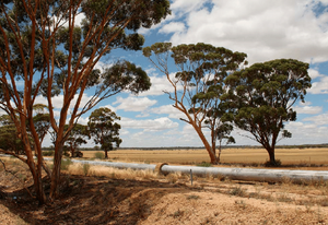
This pipeline was built 100 years ago to provide fresh water supply to the Goldfields area such as Coolgardie and Kalgoorlie. Since these areas didn't have a proper water source when the gold was discovered in this area.
Hence, this pipeline project was built. The surprising thing is that it is working even today and it is expected that it is going to work for many decades in future too.
Merredin (WA):
On your way to Perth, after Kalgoorlie, Coolgardie and Southern Cross, you'll arrive at Merredin. You can see a wonderful public silo art from the highway.
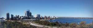
Perth (WA):
After 5 days of fantastic driving, I arrived in Perth, capital of Western Australia. Also, known as the sunniest capital city in Australia.
This completed my epic drive from Melbourne.
My Feedback about the Drive
My epic drive from Melbourne to Perth was fantastic and a great experience! Driving across the Nullarbor was a unique outback experience and it was the highlight of the drive.
Unfortunately, I had limited time and hence I had to finish it in 5 days. In my opinion, this drive requires at least 10 days. This will give you sufficient time to explore the places on the way. Also, out of 10 days, try to spend at least 4 days exclusively for Nullarbor Plain. Don't ignore it.
I would recommend this drive.
If you ever get an opportunity to drive from Melbourne to Perth (or Perth to Melbourne), just do it. Don't think too much. This requires your time, effort and money. However, it is worth and the amount of experience you get is unbelievable. Something you'll remember forever in your life.
Comments